Futurewise's current version of their TOD Transit Oriented Development Bill.Google
Washington State Legislature, click on Bill information, then type in HB 1490.
See especially page 21 Section 9 paragraphs:
Futurewise's TOD (Transit
Oriented Development) Bill HB 1490: Our response: "It's still a bull in a china
shop"
Summary of HB 1490:
Futurewise's TOD bill requires
local jurisdictions to zone for a minimum of 50 units per acre within a one-half
mile 502 acre radius of every light rail, heavy rail, and rapid bus transit
station. In response to criticisms, they have slightly moderated the density
thresholds by requiring cities to first subtract out land within each "TOD area"
given over to streets making their calculation on
the remaining "net" land area. With about one-third (their estimate
only) of a TOD given over to
right of way, that leaves about 340 acres of developable land. If 50 units are
required on each acre, that's 17,000 housing units required within each TOD
under their bill. Developers also will be exempted from parking requirements
when they develop in a TOD area and they will be rewarded in individual sites
with an additional 25% increase in density but must include about 25% of the
units between 60-80% of median. There are at least 45 rail stops planned for
the region including 18 stops in Seattle. Many bus rapid transit stations also
are planned but not yet identified. (For full text of HB 1490, it can be
accessed by googling the Legislature's website).
* Contrary to Futurewise's
assertion, current zoning within nearly all TOD areas falls well short of a
capacity of 50 units per "net" acre. Stations within the downtown core of
Seattle and Bellevue appear to be exceptions although much area around these
TOD's are oriented towards office and retail. Of nine Seattle neighborhood
stations outside downtown, drawing off information provided in the most recent
City Comprehensive Plan (See Urban Village Section-line below) each is currently
zoned for about 20-30 units per acre (Net). Only Capitol Hill's station may be
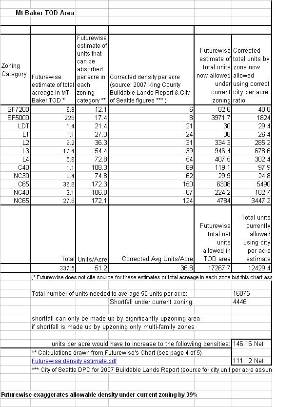
near or over the average of 50 units per acre (Net). Mt. Baker may be the most
dense of the other neighborhood stations in Seattle and it is currently zoned
for capacity of about 36 units per acre (not 51.3 units per acre as Futurewise
claims) See chart below comparing Futurewise's calculation of current capacity
to our corrected numbers:
* Futurewise has overestimated
by a significant factor how much density can be absorbed within single family
zones and just about all multi-family zoning designations. The City says (for
the 2007 Buildable Lands Report) for example that RS 5000 zones have capacity to
yield 8 units per acre when Futurewise says that zone can absorb 17.4 units per
acre. When the city says a C65 zone can absorb 150 units per acre, Futurewise
assumes that zone can handle 172.3 units per acre. When the chart above is
corrected using ratios set by the city (and based on actual performance in each
zone), the actual zoning capacity currently in the Mt. Baker TOD is 36.8 units
per acre (net). To reach 50 per acre, the area must be upzoned to accommodate
an additional 4446 units.
* Futurewise says the entire
area of a TOD must average 50 units per acre. Their bill allows cities however
to retain those low density single family areas. But, since the whole area must
"average" 50 per acre, these low densities must be off-set by even higher
densities in the remaining multi-family and commercial areas. In the above Mt.
Baker example, if all the extra density is pushed off onto the remaining one
third of total acreage not zoned single family, then those areas must be upzoned
to 146 units per acre (net) or 111 unit per acre (gross). These areas must be
upzoned to look like parts of Manhattan or S. Chicago for the entire area to
reach an average of 50 units per acre! Seattle would have to either
dramatically upzone single family areas or turn McCLellan and Rainier into S.
Chicago.
* The problem is compounded within most of the other neighborhood TOD areas in
Seattle both North and South along the rail corridor. There is even more area
given over to single family
zoning within the S.Henderson, Othello, Edmunds, Beacon Hill, and Roosevelt TOD
areas.
Northgate also has high concentrations of single family and lacks any area zoned
higher density commercial. According to the city's recently revised
comprehensive plan these TOD areas currently have average densities that range
from 4 units per acre in North Rainier (Edmonds station), 5 per acre at
Rainier/S. Henderson , 6 per acre in Edmunds/Columbia City, 6 per acre at
Othello up to about 9 per acre in Roosevelt, North Beacon Hill, and Northgate.
Around the other two stations in the neighborhoods, current densities are at 25
per acre (First Hill-Capitol Hill), and 9 units per acre around the U-District
Brooklyn station.
* The current city comprehensive plan calls for zoning that could accommodate
the following densities by 2024 within each of the neighborhood TOD areas
(source: 2008 Comp plan Urban Village Section). Note also that
neighborhoods within these TOD's all have developed neighborhood plans and
anticipate transit stations. Growth targets were set based on these
assumptions and in the last four years, city-wide we are at 50% of our 20 year
targets. Each of these urban villages where a TOD would be located are exceeding
their growth targets. Nevertheless Futurewise's bill would require these areas
to upzone for 3 times the growth called for in the Comp Plan and 20 year
targets. See chart below also:
- North Rainier (S. McClellan/Mt Baker TOD): Calls for
zoning to accommodate 15 units per acre on 453 acres around that TOD to reach
about 6.5 units per acre by 2024). This would bring the total hh's up from
1590 to about 3975 Note that under the Futurewise bill, each TOD area would
have to be upzoned to accommodate nearly 17,000 households on 500 acres
(gross) or 337 acres (net or buildable acreage within that TOD).
- Northgate would have to be zoned to accommodate
densities of 15 units per acre and a total population of 6000 households by
2024 (on 411 net acres)
- The U-District would have to be zoned to accommodate
densities of 17 units per acre for a total population of 6800 households. (on
about 400 net acres)
- Capitol Hill/First Hill would have to be zoned by 2024
to reach 28 units per acre up from 25 for a total population of 26,000 (on 400
net acres) (city ordinance calls for zoning around stations to be zoned
for an additional 30% density above 2024 growth target so here at most on
Capitol Hill, that TOD needs upzones to reach capacity of less than 40 not 50
units per acre as required under Futurewise bill)
- For all the other TOD areas in the neighborhoods
including those in SE and North Seattle (except for Capitol and the
U-District) the city's comp plan calls for zoning capacity to enable those TOD
areas to reach 6-14 units per acre by 2024. To restate: City ordinance
for areas around stations requires the city to zone these areas for about 30%
more density or capacity above these targets and that's well below
Futurewise's bill which would require 50 units per acre:
| |
|
|
|
|
|
|
|
|
|
|
|
|
9 TOD's: |
2008 |
|
units/acre |
added |
2024 |
|
units per acre |
|
Northgate |
|
|
3400 |
# |
8.5 |
2500 |
5900 |
# |
14.75 |
|
Roosevelt |
|
|
3000 |
# |
7.5 |
1000 |
4000 |
# |
10 |
|
U-District/Brooklyn |
|
5000 |
# |
12.5 |
1800 |
6800 |
# |
17 |
|
First Hill/Capitol Hill |
|
10,000 |
# |
25 |
1200 |
11200 |
# |
28 |
|
North Beacon Hill |
|
3400 |
# |
8.5 |
2500 |
5900 |
# |
14.75 |
|
North Rainier (Mt Baker) |
|
1590 |
# |
3.975 |
900 |
2490 |
# |
6.225 |
|
Columbia City (Edmunds) |
|
1750 |
# |
4.375 |
800 |
2550 |
# |
6.375 |
|
Holly & MLK (Othello) |
|
2080 |
# |
5.2 |
590 |
2670 |
# |
6.675 |
|
Rainier Beach/S.Henderson |
|
2600 |
# |
6.5 |
1200 |
3800 |
# |
9.5 |
|
|
source: 2008 Comp Plan |
|
|
|
|
|
|
|
|
|
|
current density of 9 TOD's |
32820 |
|
Growth target: |
12490 |
45310 |
|
|
|
|
|
|
|
|
|
|
|
|
|
|
City Comp Plan 2024 Total HH Target for these TOD's: |
45,310 |
|
13 units per acre net |
|
|
|
Futurewise Bill (17,000 X 9 TOD) |
153,000 |
|
50 units per acre (net |
|
|
| |
|
|
|
|
|
|
|
|
|
| |
|
City-Wide Current Capacity: |
128,000 |
|
|
|
|
|
|
There's no if ands or buts....the city's Comp Plan would
have to be altered to significantly increase densities to reach 17000 housing
units within each 502 acre TOD area (gross) or 337 acre net buildable acreage) .
* the Futurewise bill lacks adequate housing mitigation
contrary to their claims (we'll have more detail on this later)
* According to the current 2008 Comp Plan, in nine neighborhood TOD areas that
now house about 30,000 households total, The city says, these areas will have to
be zoned to accommodate an additional 15,000 units within those nine TOD areas
by 2024 (Northgate, Roosevelt, U-District, Capitol Hill, North Beacon Hill, Mt.
Baker/S.McLellan, Edmunds/Columbia City, Othello/MLK& New Holly), and S.
Henderson (Rainier Beach). In just one of those TOD's, the Futurewise Bill
requires city's to upzone these areas so that they each can accommodate 17,000
units for a total in all 9 of 153,000 units.
* In their most recent memo responding to the Coalition's column, Futurewise in
at attempt to downplay the impact of their bill on Seattle neighborhoods claims
most of the TOD areas within Seattle already are already zoned to accommodate
17,000 units or 153,000 total. According to the Comp Plan these nine areas
together now house about 30,000 households. If their claim is true that means
there's an existing remaining capacity in all nine TOD's of about 123,000
units. In all of Seattle, the 2008 Comp Plan says that under current zoning,
there is a remaining capacity available to accommodate 128,000 households.
Apparently Futurewise would have us believe that 95 percent of that capacity is
located in these 9 TOD's that make up less about 9 percent of the city's
developable land.
Also see earlier responses by Futurewise to our original column
click here to see our original column critical of their bill - followed by
our responses:
First response Jan 6 '09
Futurewise WLIHA joint letter and response to Fox Colter 1.6.09-1.pdf
Their second memo Jan 13th
containing further explanation and response to our column and concerns:
Our response to the Jan 13th memo here:
Our response to Futurewise and Low Income Housing Alliance Jan 6, 09 letter (see link
above):
Last week a column of ours was aired in local newpapers critical of a bill
about to be introduced down in Olympia by Futurewise (formerly "1000 Friends of
Washington).
click here to see our original column Their "Transit Oriented
Development" or TOD bill - as drafted with absolutely no input from affected
communities - would require cities to accommodate a minimum of 50 units per acre
within a half mile radius of all bus and light rail rapid transit stations in
our city and region. Areas like SE Seattle, Capitol Hill, U-District,
Roosevelt, Northgate that radiate out rail stations and deep into each
neighborhood (encompassing over 500 acres in each area) would have to be upzoned
to accommodate a minimum of 25,000 housing units. These areas respectively now
have current densities at 4 units per acre in SE Seattle (or 3000-4000 units),
Capitol Hill (10.8 units per acre or about 8000-10,000 units total), the
UDistrict (8 per acre 6000-8000 total), Roosevelt (6 per acre 4000-6000 total),
Northgate (4 per acre 3000-4000 total).
Click here for
full text of their bill and (see especially page 21 Section 9). The downtown
and Belltown currently contain densities of about 25 units per acre.
Acres of trees and open space and hundreds and hundreds of units lower density
lower price housing for working families, low income people, and people of color
would have to give way to much higher density and much more expensive
residential development as a result of Futurewise's Bill.
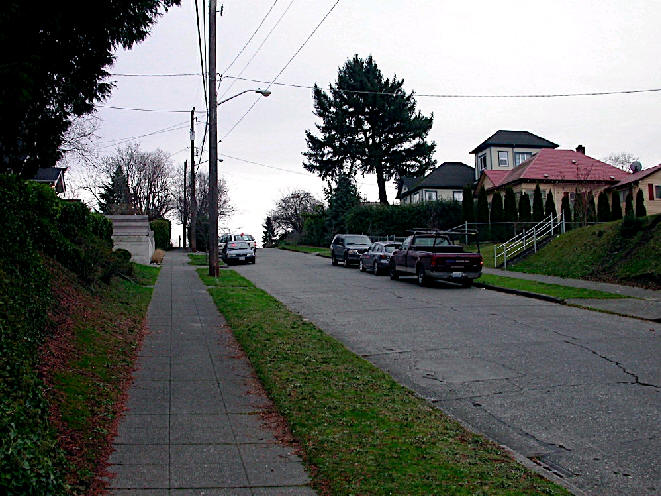
This is scale of communities now located within the TOD areas reaching out a
half mile from stations in SE Seattle and around proposed stations in N.
Seattle - these areas contain many affordable single family homes and lower
density affordable rental units. Currently, the area averages about 4 units per
acre.
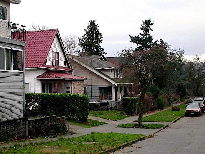
photos taken of area within TOD area at Othello and MLK Way..
In response to our column - rather than seeking us out first or more
importantly rather than meeting with the affected communities first to hear
directly their concerns and respond to them - Futurewise has merely shot back
with a fiery letter denying that their bill will have any adverse impacts on
our city's neighborhoods. And, unfortunately, they also have been joined in
their attack on us by the State-Wide Low Income Housing Alliance as co-signatory
on the letter. They too to date have not sought out the opinions and concerns of
people within these affected areas. (The Alliance is made up largely and is
primarily funded by housing authorities, cities, and non-profit housing
developers).
(click here for a copy of their joint letter)
Below we'd like to offer a response to their letter but we also invite you to
be the your own judge. Review especially p. 21 Section 9 of their bill (click on
above) and then let Futurewise and the Low Income Housing Alliance know what you
think of their bill. Better yet let members of the House Local Government
Committee know what you think of a bill designed to cram runaway
displacement-inducing densities into our neighborhoods. And please also call you
own area legislators that soon will be called on to cast a vote on this bill or
a version of it.
* This following link taken from the "Smart Growth, Smart Energy Toolkit"
defines appropriate densities for TOD areas at minimums of "12-15 units per
acre. Futurewise's 50 unit per acre threshold is over 3 times that amount.
(read midway down link). Not only are Futurewise Thresholds out of touch with
neighborhood reality..there out of touch with smart growth standards:
http://www.mass.gov/envir/smart_growth_toolkit/pages/mod-tod.html Note
also these principles state that "The zoning should be tailored to respect
the unique setting of individual stations". There is no such attempt by
Futurewise to craft legislation responsive to the unique characteristics of each
neighborhood where a station would be located.
* See page 5 of 8
click here
on Futurewise's own website. Even they say the optimum amount of density per
acre within a TOD area should be between 12-18 to as low at 4 units per acre,
and I'll quote directly from their website:
The zoning in these land uses varies, and the density is some zones is quite
low. A general benchmark for density in transit station areas is twenty units
per acre, to make high capacity transit feasible. The densities in the potential
TOD zones of Auburn range from two units per acre in the R-3 zone, to 12-18
units per acre in the R-4 and RO zones. It is important to note the densities of
less than four housing units per gross acre within the urban growth area
violation of the Growth Management Act unless they are applied exclusively to
lands with extensive critical areas.
* Responses to the Low Income Housing Alliance: We are
disappointed that they would join as signatory without first talking to us and
more importantly affected communities. And we are not at all certain that the
state-wide low income housing alliance will support amendments to the bill to
ensure that low income housing impacts will be addressed within cities required
to upzone within TOD areas.
We stand by our column as written: for more information contact, John V. Fox for
the Coalition 206-632-0668